 Tweet
Tweet
Някой би ли ми казал от къде да сваля актуална морска карта на черно море за ръчен gps garmin. Не съм работил с тези карти.
-
-
От: Трябва ми карта за Черно Море
Първоначално публикуван от Garminn Преглед на мнениеGarmin bluechart g2 Vision VEU504S-black and caspian sea
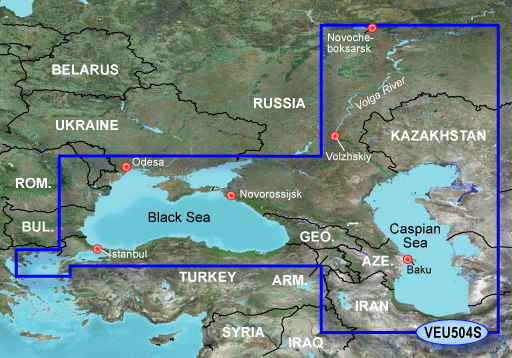
mapid 234
VEU504S Covers:
Detailed coverage of the entire Black Sea with port plans including Odesa and Trabzon. Coverage also includes the Sea of Azov, Sea of Marmara, and the Bosporus. Detailed coverage of the Caspian Sea in its entirety and the Volga River from Novocheboksarsk to Volzhskiy. Includes Chistopol' and Samara. General coverage of the North Aegean Sea
BlueChart g2 Vision
What is Bluechart® g2 Vision?
Plug an optional BlueChart g2 Vision SD card into your new Garmin chartplotter and tremendously expand its capabilities.
By adding a BlueChart® g2 Vision card to your compatible chartplotter, you'll have access to premium mapping features such as true 3D-view detailed mapping capabilities (both above and below the waterline), plus helpful Auto Guidance, high-resolution imagery, and "real picture" aerial photos of ports, harbors, marinas, waterways, navigation landmarks and other points of interest.
BlueChart g2 Vision Features:
BlueChart g2 Vision SD cards enhance the preloaded maps on your chartplotter and add a whole new dimension of exceptional features such as:
•High resolution satellite imagery, when overlaid on the chart, provides the mariner with unparalleled situational awareness.
•Aerial reference photography provides "real world" photos of ports, harbors, marinas, waterways, navigation landmarks and other points of interest, offering the mariner another powerful tool for navigating unfamiliar waters.
•Mariner's Eye View perspective provides a bird's eye view from behind the boat showing the chart information for a quick, reliable and easy position fix.
•Fish Eye View 3D perspective provides an underwater view that visually represents the sea floor according to the chart's information.
•Auto Guidance technology searches chart data to suggest the best passage to a destination.
•Fishing charts allow the mariner to hide navigation data from the SD card while leaving the bottom contours and depth soundings for their next fishing adventure.
•Includes tides, currents, marine services, coastal roads and points of interest.
•Detailed BlueChart g2 maps are included on the card to supplement the maps on your chartplotter.
BlueChart g2 Vision Compatibility:
•4x0 Series
•400x Series
•420x Series
•5x0 Series
•500x Series
•520x Series
VEU504S ID=234
http://www.megaupload.com/?d=UZH98219
http://www.megaupload.com/?d=P688O1GV
MIRROR---
http://www.megaupload.com/?d=46KSAAT4
http://www.megaupload.com/?d=IVJ1H084
Благодарение на Catymag
Това ли търсиш? Картата е дъртичка 2009 г.Nothing comes from nothing... -
От: Трябва ми карта за Черно Море
Ами колега тая http://www.garmin.bg/?s=7&i=36 е най добра за черно море според мен, но не знам от къде да я сваля
П.П немога да разбера само линка който си ми дал защо са два Rar..? Кой трябва да кача на SD Card, да ги снадя ли в един общ файл или... ?Последно редактирано от Garminn; 25-11-11, 00:49.Коментар
-
От: Трябва ми карта за Черно Море
Благодаря оправих се!Последно редактирано от Garminn; 25-11-11, 23:44.Коментар
-
От: Трябва ми карта за Черно Море
сега и на мен ми трябва карта на черно море линковете по горе не работят много ще се радвам ако някой помогнеКоментар
-
От: Трябва ми карта за Черно Море
Първоначално публикуван от kanev60 Преглед на мнение
http://gpsunderground.com/forum/garm...0-15-50-a.htmlКоментар
-
От: Трябва ми карта за Черно Море
raptor213

http://gpsunderground.com/forum/garm...0-15-50-a.html
Благодаря,колега,свалих си я от линка във формат Gmapsupp.img е, но не мога да я отворя на компютъра, със ирфан вю съм. Тъй като е доста голяма бих желал да си направя слайсове само на нашето крайбрежие-имам Мапсорс и Gmap Tool,ама не знам как да го направя. Уреда ми е гармин етрекс виста Нс х със СД карта от 2 ГБ,но свободна около половината. Друга опция е да си купя нова сд/карта пак 2 ГБ и да я кача цялата,като тази карта ще използвам само за риболов по нашето крайбрежие. Някаква по-добра идея/ Благодаря предварително.ILLEGITIMI NON CARBORUNDUMКоментар
-
От: Трябва ми карта за Черно Море
Програмата за разглеждане на морските карти на Гармин е HomePort. За нея има писано и тук, пък и Гугъл може да помогне.Nothing comes from nothing...Коментар
-
От: Трябва ми карта за Черно Море
Картата не струва. Дори картите на ГЩ са по добри. Всъщност за една груба представа върши работа, но не е актуална въобще.I get High by going DownКоментар
-
От: Трябва ми карта за Черно Море
Благодаря,колега.Първоначално публикуван от ISG Преглед на мнениеILLEGITIMI NON CARBORUNDUMКоментар
Коментар